Road trips!
Today is the first day in two months that I've spent at home, alone, with no agenda or plans or responsibilities. It's wonderful! I took two naps already.
May and June are very busy months for me, and I'll be spending a good amount of time traveling. Recently, I've been spending some quality time with my car, and in the next couple of weeks I'll be spending even more time driving. This past week the driving was mostly a bad experience. For future reference, the next time I suggest that it will just be easier to drive to Washington, DC, then New York, then back home again, remind me that IT WILL NOT. I should take the bus or train like other normal people. The combined travel time for these three legs of the journey should be about 12 or 13 hours, and yet from Tuesday through Friday I spent 19 hours driving, and about $30 in tolls. The terrible traffic I encountered and moments of getting lost in unfamiliar places could be described as a comedy of errors, and yet it WASN'T FUNNY. I was so relieved to get home on Friday night that I've been content to do absolutely nothing this weekend.
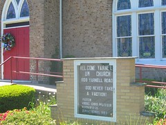
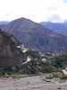
Other than this trip, the rest of the summer's road trips should be lots of fun. The good times started on Memorial Day weekend, which was a really fun weekend spent with Nate. First we hiked local landmark Mount Nittany, and on Sunday we embarked on a GeoDate. We took out a Pennsylvania Atlas, flipped a coin to choose between the pages in the vicinity of where we live, and then threw a dart at the chosen page to determine our destination. The winner? Yarnell, PA, a place so small, it's not actually a town at all! Along with nearby Rhoads, Fetzertown, Runville, and Dry Top, Yarnell is included in Boggs Township, population 2,783.
View Larger Map
It was a sunny day, and we parked at the church, were greeted by several local dogs and had a picnic by a small stream. Afterwards, we stopped in at Jack's Snack Shack for ice cream, and asked the owner, Ed, about any local attractions not to be missed. We also clarified the correct pronunciation of the town's name (according to Ed: "yar-NELL. It used to be called YAR-nell, but over the years, I'm not sure why, it changed to the more fancy pronunciation of yar-NELL.")
Ed suggested we head up Devil's Elbow road to see the "engine" carved into the rock. Ed's particularly rural pronunciation at first shocked me into expecting a silhouette of a Native American tribesman of some kind, and I was relieved to realize that he meant a train locomotive. A local attraction, the train was carved in the 1800s but its artist and reason for being seem lost to history and subject of some local speculation.
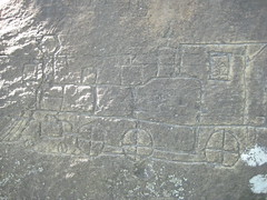
(Photo by Nate)
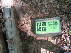
The train was pretty interesting, and while checking it out we met two families who had come to show their kids the train and go on a Geocaching excursion. Geocaching, which was a new concept to me, is a worldwide hobby for GPS and exploring enthusiasts. Containers are hidden, their coordinates and details written up online for other geocachers to seek them out. These sleuths sign a logbook and take and/or leave trinkets to be later deposited in other geocaches in other locations. (Oh, and for the record, Nate and I were calling our day a GeoDate even before we met the GeoCachers!)
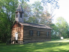
This turned into a fortuitous meeting, because our new friends told us about a local spring where we could fill up our water bottles, and pointed us towards another Geocache at a historic church about a half-hour away. Thus we continued the adventure, seeing more beautiful countryside, learning about some local history and finding another treasure trove.
I highly recommend the GeoDate as a great way to get to know someplace (or someone) new, especially on a beautiful, sunny day at the end of spring. In fact, we plan to use the dart-throwing technique in another week during our New England road trip through Maine and Vermont. Stay tuned for more adventures!
posted by Jess @ 18:02
![]()


<< Home